satellite navigation
Satellite navigation systems are used to determine positions on Earth. With their data, receiving devices can precisely calculate their geographic coordinates and altitude. The exact determination of position is particularly suitable for mobile receiving devices, such as motor vehicles, aircraft, ships and people.
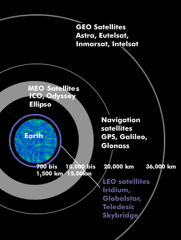
There are several satellite navigation systems, such as the U.S. GPS system, the Russian Global Navigation Satellite System( GLONASS) and European Galileo. China also has its own satellite navigation system, BeiDou; as does Japan, whose navigation system is called QZSS, which stands for Quasi Zenith Satellite System. All satellite navigation systems work with earth-orbiting satellites whose orbits are at about 20,000 km. Since navigation requires receiving signals from at least three satellites simultaneously, all satellite navigation systems have six or more satellites orbiting in multiple orbital planes. In the GPS system, for example, there are 21 active satellites in six orbits.
Satellite navigation includes timing and movement of navigation devices and can be used in air, land, and maritime navigation.
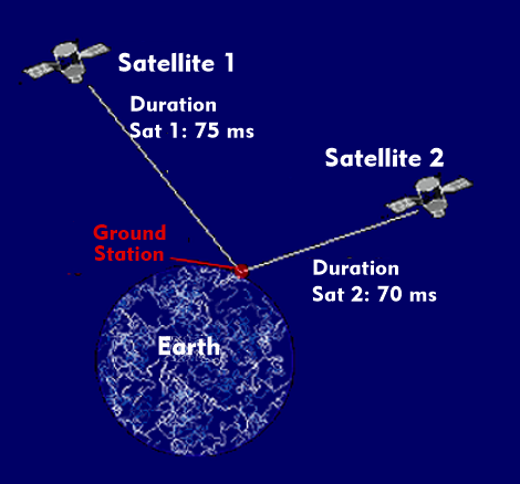
All satellite navigation systems use the same technology. The distance between the receiver and the satellite can be determined from the regularly transmitted time signals using the speed of light. Two navigation satellites are sufficient for determining geographic coordinates, but since altitude is added, the systems require at least three satellites.
The best known satellite navigation system is the GPS system. Since it is deliberately limited in its spatial resolution for civil use, navigation systems have been developed especially for air traffic control and flights with impaired visibility, with which the spatial accuracy of all satellite navigation systems can be increased by a factor of ten. These systems are called Satellite Based Augmentation Systems( SBAS). The system developed for North America is the Wide Area Augmentation System( WAAS), the European one is called European Geostationary Overlay Service( EGNOS) and the Multi-Functional Satellite Augmentation System( MSAS) developed by Asian countries.